What Then?


Napoleon was here. The bloodbath in Aspern is considered his first defeat. The Orient Express went by here. And the Aspern airfield was also here, a long-time centre of Austrian aviation and then part of the Soviet occupation zone. The village of Aspern had long been incorporated into the city of Vienna and kept a place in the hearts of people who attended the motor races that took place here until the seventies.
48° 13’ 34“ North by 16° 30’ 20“ East: the GPS data for the proposed centre of one of the continent’s largest urban-expansion projects indicate a rectangle of 31 x 21 meters, depending on the arcseconds. This rectangle allows us to measure the 240 hectares of Aspern Seestadt. We do not yet see the projected 10,500 flats or the 20,000 workplaces. In keeping with their “musical score for public space,“ the planners would like to make that space a second living room.
New urban-architecture projects look increasingly similar. More and more often, they are determined by industrial materials and building methods that are used worldwide. Looking at them gives us hardly any information about their geographical location or social nexus. It gives new meaning to the term “global village“.
Space without its context is nothing. We see what we expect to see. Where do the sediments of earlier events settle? When do they disappear from our sight? When does emptiness begin – how does it end?
(to be continued)
For German version please scroll down. (Translation: Laura Freeburn)
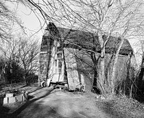


Napoleon war hier. Das Gemetzel in Aspern soll seine erste Niederlage gewesen sein. Der Orientexpress fuhr hier vorbei. Und hier lag das Flugfeld Aspern, das lange das Zentrum der österreichischen Luftfahrt und dann Teil der sowjetischen Besatzungszone war. Das Dorf Aspern war längst in das Stadtgebiet von Wien einbezogen worden und jedenfalls unter den Besuchern der Autorennen beliebt die bis in die Siebziger Jahre hier veranstaltet wurden.
48° 13’ 34“ Nord - 16° 30’ 20“ Ost: Die GPS-Daten des gedachten Zentrums eines der größten Stadterweiterungsprojekte des Kontinents sind - abhängig von den Winkelsekunden - auf eine Fläche von 31 x 21 Meter genau. Von diesem Rechteck aus vermessen sich die 240 Hektar der Seestadt Aspern. Die projektierten 10.500 Wohnungen sehen wir noch nicht, auch nicht die 20.000 Arbeitsplätze. Die Planer möchten gemäß ihrer „Partitur des öffentlichen Raums“ diesen zum zweiten Wohnzimmer machen.
Neue Stadt-Architekturen sehen zunehmend ähnlich aus. Sie werden immer mehr von weltweit eingesetzten industriellen Materialien und Bauweisen bestimmt. Der Anblick liefert uns kaum Informationen über den geografischen Standort und den sozialen Konnex. Eine andere Bedeutung von "global village“.
Raum ohne seinen Kontext ist nichts. Wir sehen, was wir erwarten zu sehen. Wohin versickern die Sedimente früherer Ereignisse? Wann treten sie aus unserem Blick? Wann beginnt Leere - wie endet sie?
(wird fortgesetzt)

